A Rushed I-15 High-density Zoning Corridor Proposal
By Michelle Peot
Background
Utah state law now requires a moderate income housing plan for counties that meet a population threshold of 5,000 in unincorporated counties. An analogous rule applies to municipalities. To comply, Washington County is proposing a new high density, lower income, multi-family zoning corridor along I-15 on unincorporated county land. This new Planned Development Multifamily zone would span approximately 1 mile on each side of I-15 from Hurricane exit 16 to Pintura exit 31. The proposed zone would allow density up to 18 units per acre, and buildings up to 40 feet in height (4 stories). The minimum development size is 5 acres, with a minimum density of 50 housing units.
The proposal passed the Washington County Planning and Zoning Committee after an improperly noticed public hearing. A new public hearing has been scheduled for Tuesday, March 17th at 4:00pm prior to a possible County Commissioner vote.
Proposal shortcomings
This proposal feels like a bandaid rather than a holistic regional solution that addresses the need for working family housing in context with other development pressures. Second homes, tourism, and short-term rentals all contribute to the lack of housing inventory that in turn drive up home and rental prices.
Other concerns include:
Diminishing the scenic quality of the landscape
Taxpayer burden for running sewer, water, road infrastructure to far-reaching, rural portions of the county
Air pollution from construction along a windy corridor
Skepticism of intent
The proposal defines a moderate income housing unit as one where a household whose income is no more than 80% of the area median income is able to occupy the housing unit, and it restricts short-term rentals. However, there are no restrictions on this being a second home, longer-term vacation rental, or having the rental cost be excessive relative to income to intentionally screen out moderate income families.
Furthermore, there are no schools, public transportation, or amenities available in these far-reaching rural areas for families who may lack access to reliable private transportation. It's questionable whether this proposal would serve the population it claims to target, or be yet another kickback to developers building second homes, vacation homes, and higher end 30-day+ rentals.
Alternative solution
The ideal solution would be to formulate a county-level plan that addresses the root causes of housing unaffordability by providing realistic solutions that locate working families closer to employment, schools, public transportation, and amenities. From an infrastructure perspective, it’s more cost effective to colocate these developments with, or close to, existing water and sewer service areas. For example, limiting the zone from Leeds exit 22 southward on the east side of I-15 could more easily utilize existing infrastructure thereby reducing taxpayer expense.
The natural landscape of our area is a draw for residents and visitors alike. By dispersing and blending higher density housing throughout the county, we would also avoid creating a corridor of 4-story housing units as the gateway to our community.
What you can do
Public hearing and submitting comments
The public hearing will be held on March 17th, 2026 at 4:00 PM in the Washington County Commission Chambers located at 111 East Tabernacle, St. George, Utah.
If you cannot attend the public hearing, comments may be submitted to the County Commissioners as follows:
Victor Iverson: victor.iverson@washco.utah.gov; 435-301-7000 (option 0)
Adam Snow: adam.snow@washco.utah.gov; 435-301-7000 (option 0)
Gil Almquist: gil.almquist@washco.utah.gov; 435-301-7000 (option 0)
Comments should be submitted prior to March 17th to allow the Commissioners and staff to process them in time for a possible vote on the 17th.
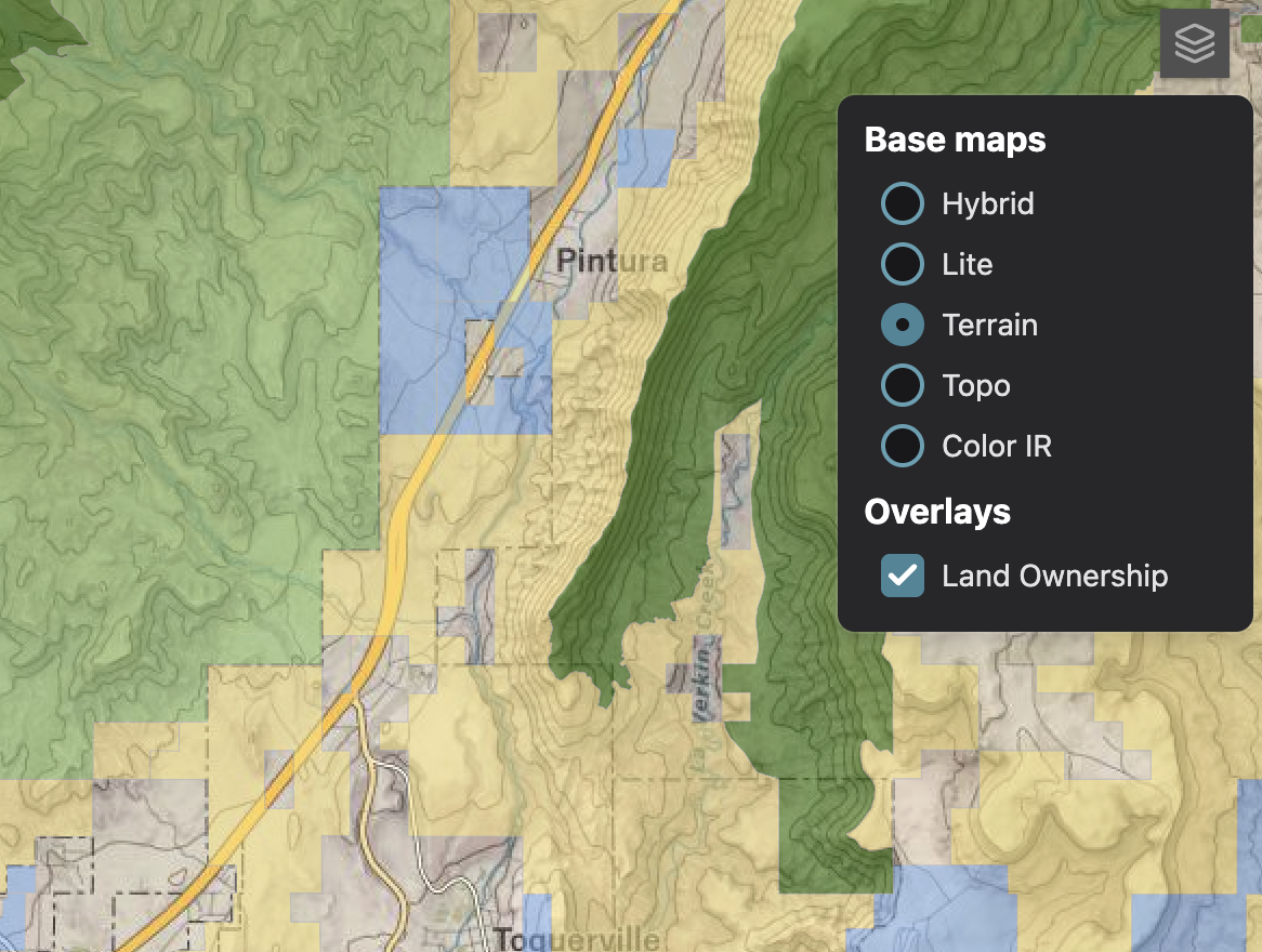
How to tell what is unincorporated county land
Visit the Utah State Parcels map to see land jurisdiction. Click the stacked squares icon on the right to switch the base maps layer to Terrain to more easily view municipal boundaries. Under overlays check Land ownership to distinguish between federal, state, and private land. With this overlay private land is gray, BLM land is yellow, UT State Trust land is blue, Forest Service land is green, and National Park land is purple.